|
|
 |


|
|
|
|
|
|
|
|
|
|
|
lionoferebor
Rohan
Jul 26 2015, 3:18am
Post #1 of 3
(1143 views)
Shortcut
|
|
Thorin's Halls
|
Can't Post
|
|
I'm not sure if this should go on "The Hobbit" or "Reading" board, so I'll post it here. Also, I apologize if this has been discussed before.
I'm looking at a map from Karen Wynn Fonstad's Middle Earth Atlas and it appears Thorin's Halls were located in the lower part of the upper region of the Ered Luin, just north of the Gulf of Luin.
Looking at another map, I see that during the First Age (before the Gulf of Luin split the Ered Luin in two) Nogrod was located in the south and Belegost in the north. Toward the end of the First Age both cities were destroyed in the drowning of Beleriand and the Gulf of Luin was created splitting the mountain range in two.
While the maps are informative I'm having trouble deciphering where the Gulf of Luin was located in relation to the ruins of Nogrod and Belegost. And, furthermore, where Thorin's Halls were located in relation to either city.
Can anyone shine some light on this?
|
|
|
Otaku-sempai
Immortal

Jul 26 2015, 12:10pm
Post #2 of 3
(1100 views)
Shortcut
|
Thorin's Halls were said to be in the Northern Ered Luin, but there is no clear indication of exactly where they were. Fonstad's guess is probably as good as any.
I do question her choice for the placement of Belegost. The Silmarillion places both cities near Mount Dolmed, with Belegost located perhaps 25 to 30 miles north of Nogrod.
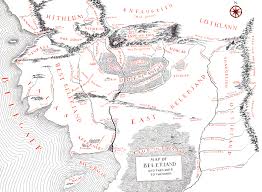
The key to figuring out what goes where is the realization that the Isle of Himling in the Third Age is analogous to the hill of Himring in the First Age.
Citing The Shaping of Middle-earth (HOME IV), Fonstad placed Belegost farther south, approximately 150 miles south of Nogrod. The problem is that her placement is inconsistent. On her maps of the First Age, she has Belegost at a location that would have been exactly where the range of the Blue Mountains was broken in two at the end of the First Age. Belegost would have been drowned beneath the Gulf of Lune. Her maps of the Second Age show Belegost an additional 150 miles south of where she previously placed it (a good 300 miles from the site of Nogrod). What is comes down to is that The Atlas of Middle-earth gives two different locations for Belegost, both of which disagree with The Silmarillion.
"At the end of the journey, all men think that their youth was Arcadia..." - Phantom F. Harlock
(This post was edited by Otaku-sempai on Jul 26 2015, 12:23pm)
|
|
|
Otaku-sempai
Immortal
Jul 26 2015, 1:12pm
Post #3 of 3
(1083 views)
Shortcut
|
Mount Dolmed isn't marked on any Third Age map, but it would be on the western side of the Northern Blue Mountains, about 150 miles from the Gulf of Lune. There is a dense forest directly south of Dolmed and to the north a river flows out of the Ered Luin, flowing south until it reaches the harbor of Forlond in the Gulf of Lune. The site of Mount Rerir would be about 120 miles further north, but it seems to be broken up a bit by the time of the Third Age.
"At the end of the journey, all men think that their youth was Arcadia..." - Phantom F. Harlock
|
|
|
|
|